
Format
NON-DIGITAL - Printed Maps
6 record(s)
Type of resources
Topics
Keywords
Contact for the resource
Provided by
Formats
Representation types
Update frequencies
Status
draft
-
These data, reported in various volumes of CSIRO's "Oceanographical Station List" series between 1952 and 1957, comprise mainly measurements of temperature, salinity, nitrate, phosphate, and dissolved oxygen at estuary mouths and upstream for various distances, ranging from a few miles to almost 150 miles in some cases: e.g. for Tasmania's Derwent River, 20 stations were measured including various tributaries (Clyde, Ouse, Nive and Shannon) as well as lakes in the river system (Great Lake, Lake St. Clair). Sampling started in the 1940s and included the Nerang and Coomera Rivers, Moreton Bay and Brisbane River, Logan River and Dunwich Oyster Lease (QLD); Richmond River, Clarence River, Macleay River, Hastings River, Manning River, Port Stephens, Tilligerry Creek, Hawkesbury River, Middle Harbour and Port Jackson, Georges River-Botany Bay, Port Hacking, Lake Illawarra, Shoalhaven River, Jervis Bay, Clyde River, Moruya River, Tuross River, and Wagonga Inlet (NSW); Port Phillip Heads (VIC); and Tamar River, Derwent River, Huon River, D'Entrecasteaux Channel, Lake Dobson, and Penna Dam (TAS). In the early 1950s the study was extended to Fitzroy River, Mary River, Gladstone Harbour, Sandy Island Strait and Moreton Island Lagoon (QLD); Maianbar-Port Hacking and Lake Macquarie (NSW); Pittwater (TAS); and King George Sound, Wilson's Inlet, Nornalup Inlet, Hardy Inlet, Leschanault Inlet, Peel-Harvey Estuary and Swan River (WA). 24-hour studies were carried out at some of the sites, and bottom samples also taken for measuring phosphorus, iron, organic carbon and total nitrogen. By 1955-6, sampling was being mostly discontinued in favour of coastal station monitoring, with the exception of Lake Macquarie which was at that time the focus of a major study.
-
This publication series from CSIRO Fisheries (later CSIRO Fisheries and Oceanography) over the period 1951-1970 contains hydrological and (some) plankton data from Divisional and chartered research vessels, commercial fishing vessels and merchant ships, coastal stations, and some estuarine and onshore waters from the period 1938-1966, compiled under the direction of D.J. Rochford (to 1959) and later A.D. Crooks, among other contributors. Data presented includes measurements from the vessels "Warreen", "Derwent Hunter", "Weerutta", "Marelda", "Estelle Star", "Investigator", "Degei", "Lancelin" ""Queenborough", "Quickmatch", "Warrego", plus numerous commercial fishing vessels and merchant ships, from all regions of Australia plus observations from "Magga Dan" in Antarctic waters in 1959 (vol. 44). Vols. 1-3 deal with "Warreen" data from 1938-1950. Several volumes (5-7, 9-10, 12-13, 15-16, 21, 26, 29, 32) cover estuarine data from Queensland, New South Wales, Victoria and Tasmania from 1940-56. Other volumes cover hydrological stations at Port Hacking (vols. 34, 42, 47, 52, 81-86), Eden (vol. 35), Rottnest Island and Port Moresby (vol. 49), Port Jackson and Wollongong (vol. 87), and Maria Island (vol. 88), as well as numerous other stations sampled less intensively. A number of volumes cover fisheries hydrology in connection with Australian tuna fishing grounds in South Australia and New South Wales between 1960 and 1966. Plankton studies are mainly covered in vols. 1-3, 19 and 22-23. A few volumes also describe analyses of bottom deposits (vols. 13, 16) and drift bottle releases and recoveries (vols. 78-79). For more details, see the full list of titles available via the "documentation" link. Individual parts of this series will be described in separate metadata entries in due course.
-
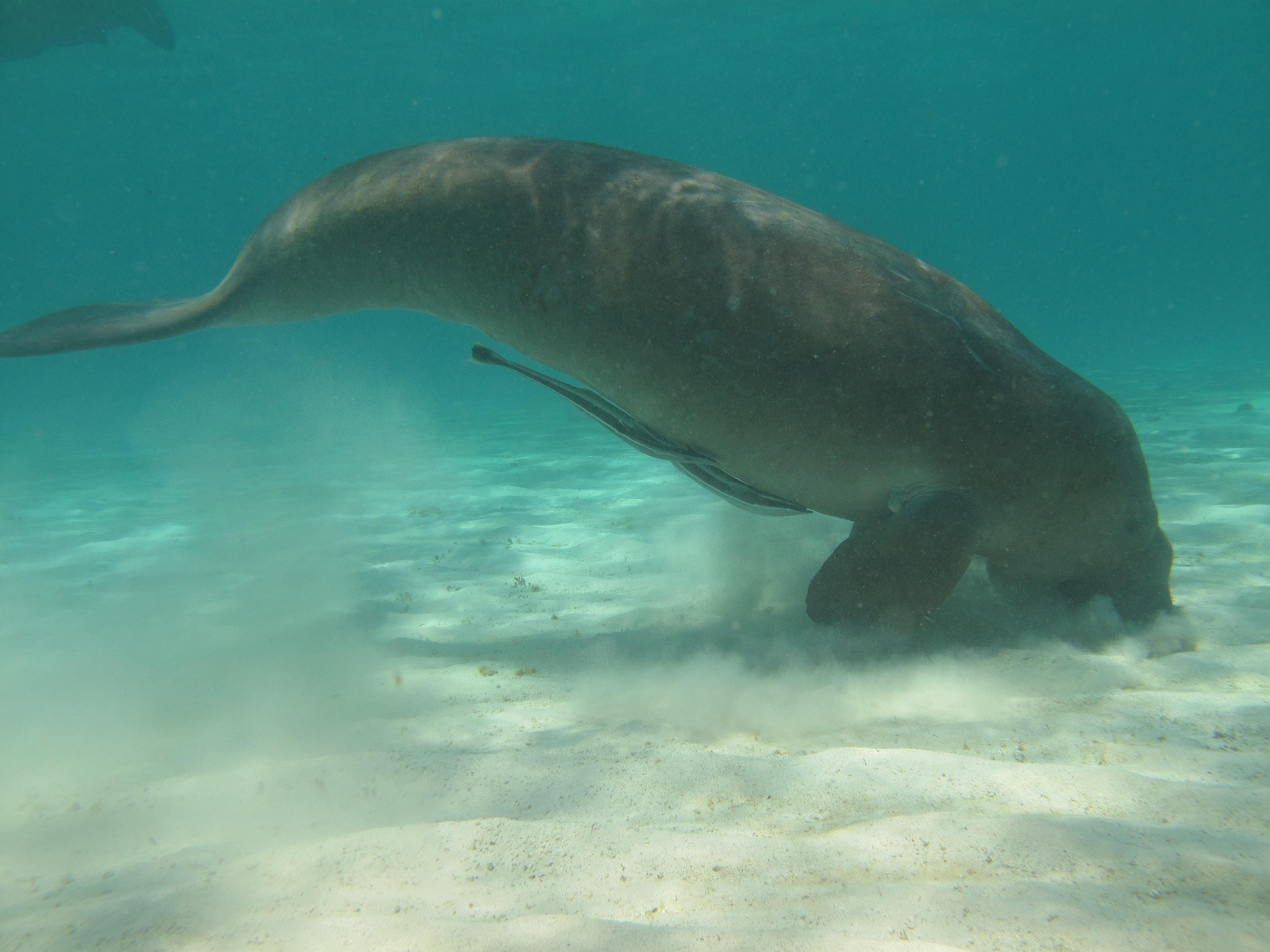
Dugongs (Dugong dugon) are listed as vulnerable on the IUCN Red List of Threatened species and as other specially protected fauna in WA under Schedule 7 of the Wildlife Conservation (Specially Protected Fauna) Notice 2015). Gaps in our knowledge in Western Australia include having a good understanding of the species’ distribution, abundance and high use areas across the northwest. This 3-year project (2014-2017) integrated Indigenous knowledge and scientific observations from field surveys to better understand the distribution, abundance and movements of dugong in the Kimberley region. The data collected also provides a baseline for future monitoring and management. This medata record relates to raw and processed aerial survey data of marine fauna collected between 21st September 2015 and 8th October 2015 in Kimberley coastal waters to the 20m bathymetry line, comprising dugongs (Dugong dugon), Australian snubfin dolphins (Orcaella heinsohni), other dolphins (bottlenose, spinners, false killer whales), humpback whales (Megaptera novaeangliae) and large, mostly green turtles (Chelonia mydas). The WA Department of Biodiversity Conservation and Attractions (DBCA, ex-DPaW) and CSIRO provided additional resources to extend the North Kimberley dugong aerial survey boundary westwards (Broome to just past Port Hedland) to cover the South Kimberley-Pilbara coastal regions, to close the last remaining knowledge gap of the dugong distribution and abundance in Australia. This additional survey was completed in May 2017. Data from a trial movement study undertaken between 1-18th August 2016 also forms part of this metadata record. Five dugongs were tagged with Telonics manatee/dugong tags. GPS and ARGOS satellite detection locations and dive data were downloaded weekly from the ARGOS web site.
-
This dataset contains hydrological and plankton data collected by FRV "Warreen" over the period February 1947-October 1950 in western and south-western Australian waters. Data included comprise depth, temperature, phosphate, nitrate, dissolved oxygen and chlorinity readings, and the results of plankton net tows reported as abundances of diatoms, crustacea (including krill and copepods), chaetognaths, coelenterates, fish eggs and larvae, mollusca and tunicates. These voyages were made while "Warreen" was stationed in Western Australia after returning from war duties and include voyage nos. 29 (July 1947) through 34 (April-June 1949) plus others of which details are not yet collated. Regions visited span the area from North West Cape to Albany and round into the Great Australian Bight. The data were published in a volume of CSIRO's "Oceanographical Station List" series.
-
This dataset contains hydrological and plankton data collected by FRV "Warreen" over the period May 1938-July 1942 in south-eastern Australian waters. Data included comprise depth, temperature, phosphate, nitrate, pH, dissolved oxygen and chlorinity readings, and the results of plankton net tows reported as abundances of crustacea (including krill and copepods), chaetognaths, coelenterates, fish eggs and larvae, mollusca and tunicates. Voyages in 1938-1939 were largely exploratory in nature, while those in 1940-1942 aimed at biannual sampling of specified transect lines ranging from Byron Bay to off Tasmania. Details of fish collections from these voyages were published elsewhere. "Warreen" was seconded for war work in September 1942 and this sequence of observations ceased. The data were published in 2 volumes of CSIRO's "Oceanographical Station List" series. Volume 1 of the published data is prefaced by a description of the "Warreen". Additional data was added in Dec 2010 with the digitization of the zooplankton records from the Warreen cruises of 1938-1942. This dataset includes surface zooplankton observations with synoptic oceanographic conditions.
-
Drift bottles and drift cards are two of the oldest methods used to trace ocean currents. Drift bottles were were released by CSIRO's division of Fisheries and Oceanography from various locations along Australia's eastern coast between 1938-40, and off Western Australia between 1954-57. Drift cards have been released from various locations around Australia, and off South Africa since about 1969. The PDF documents under the links section contain most of the information available via the Datacentre, No raw data is associated with this record.